Page 1 of 1
How to determine miles...on water
Posted: Tue Sep 08, 2015 10:02 am
by wrd1972
I want to determine the miles by water from point A to point B, before actually doing it. Is there a sight that can determine this in the same way one might do it by road?
-Thanks
Re: How to determine miles...on water
Posted: Tue Sep 08, 2015 10:18 am
by Reiner
I don't think there is something like MapQuest for waterways but you can use Google Earth to map it or with Garmin GPS software if available.
Re: How to determine miles...on water
Posted: Tue Sep 08, 2015 11:10 am
by sunedog
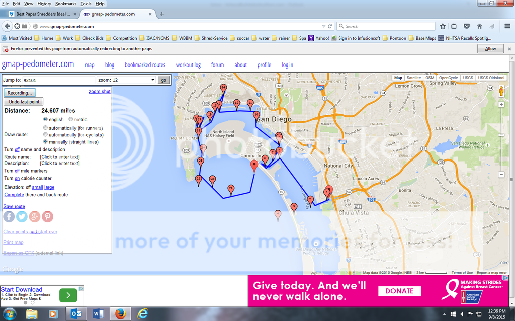
I hadn't thought of this until you asked, but try this: Go to this mapping site I used to use to measure how far I was running.
http://www.gmap-pedometer.com
Quickest way to get the map into your neighborhood is to enter your zip code in the "jump to" block at the top. Once there, drag and zoom to your starting point. Click the "manually - draw straight lines" radio button next to "draw route." Double click your starting point. Move your cursor to your next point and double click. The map will draw a line between your two points and tell you how far the distance is. Keep double clicking your route and the map will accumulate the mileage of the route. Click "undo last point" at the top if you want to erase a segment.
Re: How to determine miles...on water
Posted: Tue Sep 08, 2015 11:33 am
by curtiscapk
if it is a corp lake they have great maps that show all there marked mile marker signs. That should give you a pretty accurate idea.
http://www.nwk.usace.army.mil/Locations ... nLake.aspx
second under the maps and brochures tab for my home lake.
Re: How to determine miles...on water
Posted: Tue Sep 08, 2015 11:43 am
by wrd1972
sunedog wrote:I hadn't thought of this until you asked, but try this: Go to this mapping site I used to use to measure how far I was running.
http://www.gmap-pedometer.com
Quickest way to get the map into your neighborhood is to enter your zip code in the "jump to" block at the top. Once there, drag and zoom to your starting point. Click the "manually - draw straight lines" radio button next to "draw route." Double click your starting point. Move your cursor to your next point and double click. The map will draw a line between your two points and tell you how far the distance is. Keep double clicking your route and the map will accumulate the mileage of the route. Click "undo last point" at the top if you want to erase a segment.
This worked perfectly. Thanks.
Select "straight lines" then record. My guess was dead on for end to end on my lake but my proposed journey to another lake would be 58 miles. Might give that one a bit more thought.
Re: How to determine miles...on water
Posted: Tue Sep 08, 2015 12:55 pm
by Reiner
http://www.gmap-pedometer.com
Thanks for sharing, that is a great site/tool. Just mapped my Sunday cruise with the family, great weather and the Ocean temp is in the 70's.
Re: How to determine miles...on water
Posted: Tue Sep 08, 2015 2:49 pm
by PlaynDoc
I use Navionics app. Plan route, take it with you...
Re: How to determine miles...on water
Posted: Tue Sep 08, 2015 5:10 pm
by Spoiledrotten
wrd1972 wrote:sunedog wrote:I hadn't thought of this until you asked, but try this: Go to this mapping site I used to use to measure how far I was running.
http://www.gmap-pedometer.com
Quickest way to get the map into your neighborhood is to enter your zip code in the "jump to" block at the top. Once there, drag and zoom to your starting point. Click the "manually - draw straight lines" radio button next to "draw route." Double click your starting point. Move your cursor to your next point and double click. The map will draw a line between your two points and tell you how far the distance is. Keep double clicking your route and the map will accumulate the mileage of the route. Click "undo last point" at the top if you want to erase a segment.
This worked perfectly. Thanks.
Select "straight lines" then record. My guess was dead on for end to end on my lake but my proposed journey to another lake would be 58 miles. Might give that one a bit more thought.
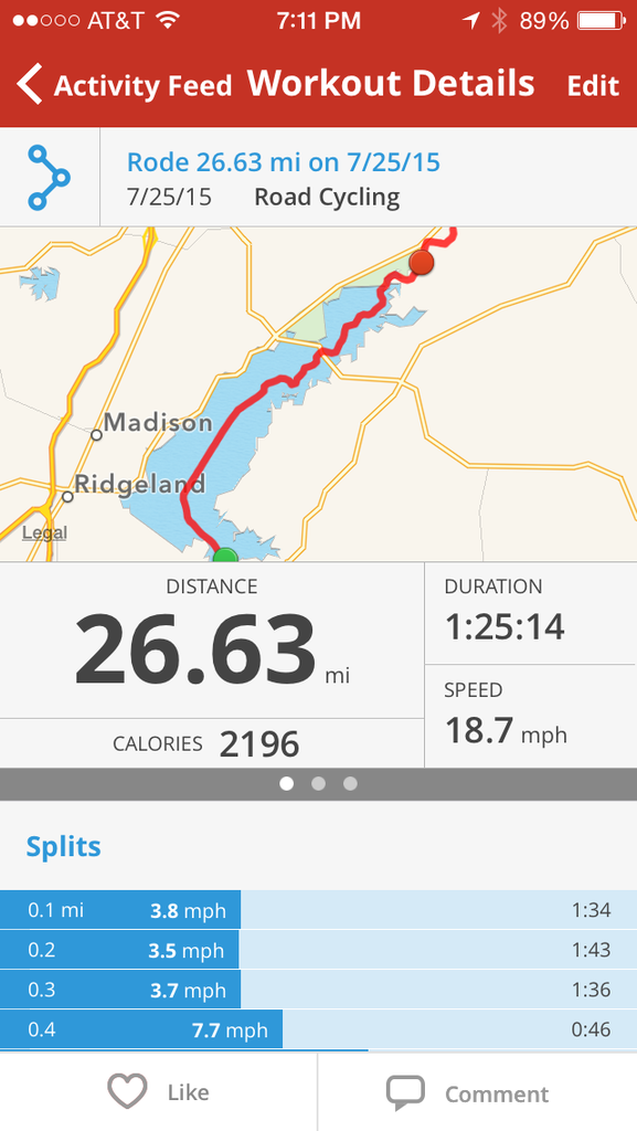
I was going to suggest something like Mapmyride, which is what I use when riding my bicycle. It works perfectly on my boat, as well to see how far I've traveled.
This is an example of what mine tracks:
Re: How to determine miles...on water
Posted: Tue Sep 08, 2015 5:32 pm
by smltooner
wrd1972 wrote:sunedog wrote:I hadn't thought of this until you asked, but try this: Go to this mapping site I used to use to measure how far I was running.
http://www.gmap-pedometer.com
Quickest way to get the map into your neighborhood is to enter your zip code in the "jump to" block at the top. Once there, drag and zoom to your starting point. Click the "manually - draw straight lines" radio button next to "draw route." Double click your starting point. Move your cursor to your next point and double click. The map will draw a line between your two points and tell you how far the distance is. Keep double clicking your route and the map will accumulate the mileage of the route. Click "undo last point" at the top if you want to erase a segment.
This worked perfectly. Thanks.
Select "straight lines" then record. My guess was dead on for end to end on my lake but my proposed journey to another lake would be 58 miles. Might give that one a bit more thought.
I just tried this site and it works great and is very accurate.
Thx for posting.
Re: How to determine miles...on water
Posted: Tue Sep 08, 2015 6:58 pm
by sunedog
Glad you guys like
http://www.gmap-pedometer.com. And spoiledrotten, I use the mapmyrun app for cycling as well. Not doing as much running as I used to since I've had four knee surgeries.
